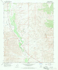
1967 Map of Wikieup
USGS Topo · Published 1970About this map
The Big Sandy River cuts a wide, braided path through the center of this Mohave County landscape, defining the layout of ranching and transit in the late 1960s. The settlement of Wikieup sits along the western bank, supported by infrastructure like a Landing Strip and a roadside Rest Area. The map reveals the practical necessities of desert life, from a Cem located near the riverbanks to family-named outposts like Hopewell Ranch and Meduele Ranch. Numerous ephemeral drainages, including Bitter Creek, Sycamore Creek, and Bronco Wash, feed into the river valley from the surrounding heights. Industrial activity is noted by several Borrow Pits and a Borrow Pit near the river, while a Jeep Trail navigates the more difficult terrain to the east, past landmarks like Cofer Hot Spring.
Find a feature on this map
22 named features on this map. Tap any name to fly to it.
Don’t see what you’re looking for? This feature index may not catch every label — zoom into the map to look around manually.
Map Details
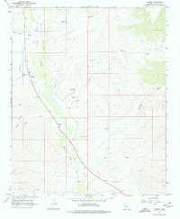
Editions of this 1967 Wikieup Map
2 editions found
Other maps of this area

1923 · Signal
USGS Topo · 1:250,000

1942 · Signal
USGS Topo · 1:250,000

1950 · Prescott
USGS Topo · 1:250,000

1954 · Prescott
USGS Topo · 1:250,000

1958 · Prescott
USGS Topo · 1:250,000

1959 · Prescott
USGS Topo · 1:250,000

1960 · Prescott
USGS Topo · 1:250,000

1965 · Prescott
USGS Topo · 1:250,000
1967 · Groom Spring
USGS Topo · 1:24,000
1967 · Gunsight Canyon
USGS Topo · 1:24,000