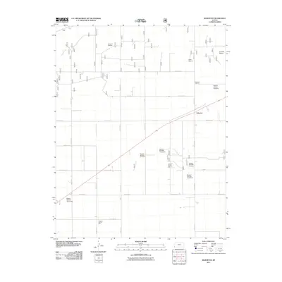
2011 Map of Wilburton
USGS Topo · Published 2011About this map
Wilburton sits at a crossroads of the High Plains in Morton County, where the landscape is defined by vast grazing lands and the energy industry. This early 21st-century survey documents a region partitioned into numbered and named grazing units, including Artesian Pasture, Sandhills Pasture, and Coen Pasture. The economic life of the area is further evidenced by the Wilburton Oil and Gas Field and the Taloga Oil and Gas Field, highlighting the region's reliance on mineral extraction alongside traditional ranching. Local landmarks such as the Wilburton Cemetery and Happy Ditch provide points of interest for genealogists and local historians tracing the footprint of this rural community. The organized grid of county roads, including County Road H and County Road G, facilitates movement across this sparse, functional landscape.
Find a feature on this map
23 named features on this map. Tap any name to fly to it.
Don’t see what you’re looking for? This feature index may not catch every label — zoom into the map to look around manually.
Map Details
Editions of this 2011 Wilburton Map
This is the sole edition of this map. No revisions or reprints were ever made.
Other maps of this area

1954 · Perryton
USGS Topo · 1:250,000

1955 · Dodge City
USGS Topo · 1:250,000

1958 · Perryton
USGS Topo · 1:250,000

1958 · Dodge City
USGS Topo · 1:250,000

1959 · Dodge City
USGS Topo · 1:250,000
1973 · Elkhart South
USGS Topo · 1:24,000

1973 · Rolla NW
USGS Topo · 1:24,000

1973 · Elkhart NE
USGS Topo · 1:24,000
1973 · Elkhart North
USGS Topo · 1:24,000
1973 · Elkhart NW
USGS Topo · 1:24,000