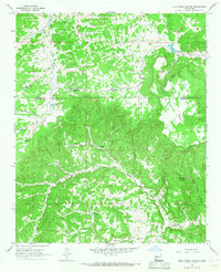
1964 Map of Wild Horse Canyon
USGS Topo · Published 1967About this map
Woods Ranch and Hertz Ranch anchor the high desert landscape of central New Mexico during the mid-1960s, a region defined by its vital water infrastructure. The topography is dominated by the massive Techado Mesa and the winding course of the Rio Salado, where life is sustained through an intricate network of tanks and windmills. This survey documents the critical reliance on features like the Dog Windmill, Sissy Windmill, and Lower Pine Windmill to support cattle ranching in an arid environment. The map also captures the transition between Valencia and Catron Counties, showing the rugged drainage patterns of Cebolla Canyon and Wild Horse Canyon. Several natural springs, including Techado Spring and Onion Spring, provide rare permanent water sources in this remote western interior.
Find a feature on this map
30 named features on this map. Tap any name to fly to it.
Don’t see what you’re looking for? This feature index may not catch every label — zoom into the map to look around manually.
Map Details
Editions of this 1964 Wild Horse Canyon Map
This is the sole edition of this map. No revisions or reprints were ever made.
Other maps of this area

1917 · Broom Mountain
USGS Topo · 1:125,000

1954 · Socorro
USGS Topo · 1:250,000

1958 · Socorro
USGS Topo · 1:250,000

1962 · Socorro
USGS Topo · 1:250,000
1964 · Sand Canyon
USGS Topo · 1:24,000
1964 · Cebollita Peak
USGS Topo · 1:24,000

1964 · Third Canyon
USGS Topo · 1:24,000

1964 · Wiley Mesa
USGS Topo · 1:24,000
1964 · Bonine Canyon
USGS Topo · 1:24,000

1964 · Pasture Canyon
USGS Topo · 1:24,000