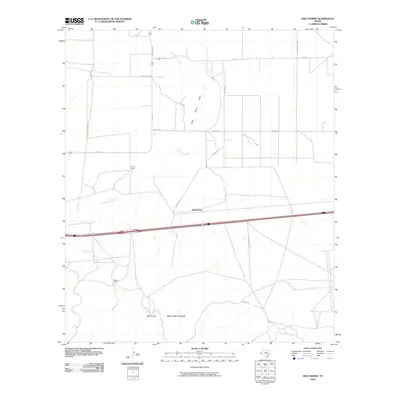
2010 Map of Wild Horse
USGS Topo · Published 2010About this map
Wylie Mountains rise in the southern reaches of this landscape, marking a stark contrast to the alluvial plains of the north. The area is characterized by vast open ranchlands and the intermittent drainage of Wild Horse Creek and Wild Horse Draw, which wind through the basin toward the namesake settlement of Wild Horse. Transportation in this part of Culberson County relies on a grid of rural routes such as Fm 2185 and Sunsites Rd, which connect isolated outposts like Durrill Camp and Harper Ranch. The map reveals a high-desert environment where water sources and topography dictated the placement of early ranching infrastructure and local roads.
Find a feature on this map
14 named features on this map. Tap any name to fly to it.
Don’t see what you’re looking for? This feature index may not catch every label — zoom into the map to look around manually.
Map Details
Editions of this 2010 Wild Horse Map
This is the sole edition of this map. No revisions or reprints were ever made.
Other maps of this area

1892 · Chispa
USGS Topo · 1:125,000

1895 · Chispa
USGS Topo · 1:125,000

1897 · Chispa
USGS Topo · 1:125,000

1906 · Van Horn
USGS Topo · 1:125,000

1954 · Van Horn
USGS Topo · 1:250,000

1958 · Van Horn
USGS Topo · 1:250,000

1959 · Marfa
USGS Topo · 1:250,000
1964 · Goat Canyon
USGS Topo · 1:24,000

1964 · Wild Horse
USGS Topo · 1:24,000

1964 · Watson Ranch
USGS Topo · 1:24,000