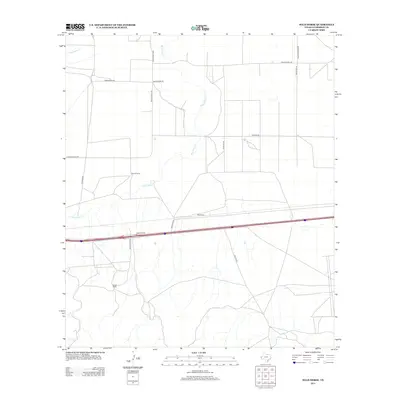
2013 Map of Wild Horse
USGS Topo · Published 2013About this map
Wild Horse Cr meanders through the central basin of this Culberson County landscape, defining the drainage patterns and historical ranching boundaries of the region. The map documents a sparsely settled desert terrain where family and commercial ranching operations like Harper Ranch and Durrill Camp established footholds. Transportation is centered on a network of ranch-to-market corridors, including Ranch Road 2809 and Ranch Road 2185, which intersect with more modern infrastructure like Frontage Rd. This 2013 survey illustrates the enduring cattle-country character of the West Texas high desert, showing how water sources like Hackberry Cr and seasonal drainages dictated the placement of roads and remote outposts.
Find a feature on this map
17 named features on this map. Tap any name to fly to it.
Don’t see what you’re looking for? This feature index may not catch every label — zoom into the map to look around manually.
Map Details
Editions of this 2013 Wild Horse Map
This is the sole edition of this map. No revisions or reprints were ever made.
Other maps of this area

1892 · Chispa
USGS Topo · 1:125,000

1895 · Chispa
USGS Topo · 1:125,000

1897 · Chispa
USGS Topo · 1:125,000

1906 · Van Horn
USGS Topo · 1:125,000

1954 · Van Horn
USGS Topo · 1:250,000

1958 · Van Horn
USGS Topo · 1:250,000

1959 · Marfa
USGS Topo · 1:250,000
1964 · Goat Canyon
USGS Topo · 1:24,000

1964 · Wild Horse
USGS Topo · 1:24,000

1964 · Watson Ranch
USGS Topo · 1:24,000