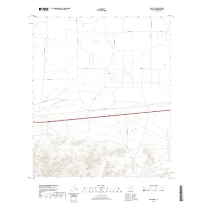
2019 Map of Wild Horse
USGS Topo · Published 2019About this map
Wild Horse Cr and the ephemeral Wild Horse Draw define this arid landscape in Culberson County. The area reflects a classic West Texas transition where open rangeland meets more complex topography to the south. Historically significant transportation routes traverse the terrain, including a section of the Old Bankhead Hwy, an early transcontinental auto road. Modern infrastructure is represented by Interstate 10, which cuts through the central portion of the map, contrasting with the network of gravel and dirt ranch roads like Sunsites Rd and Brookshire Rd. The presence of the Wild Horse Ranch indicates the continued importance of large-scale land holdings in this high-desert environment, while drainage features like Hackberry Cr illustrate the natural water courses that have dictated settlement and passage through the region for generations.
Find a feature on this map
16 named features on this map. Tap any name to fly to it.
Don’t see what you’re looking for? This feature index may not catch every label — zoom into the map to look around manually.
Map Details
Editions of this 2019 Wild Horse Map
This is the sole edition of this map. No revisions or reprints were ever made.
Other maps of this area

1892 · Chispa
USGS Topo · 1:125,000

1895 · Chispa
USGS Topo · 1:125,000

1897 · Chispa
USGS Topo · 1:125,000

1906 · Van Horn
USGS Topo · 1:125,000

1954 · Van Horn
USGS Topo · 1:250,000

1958 · Van Horn
USGS Topo · 1:250,000

1959 · Marfa
USGS Topo · 1:250,000
1964 · Goat Canyon
USGS Topo · 1:24,000

1964 · Wild Horse
USGS Topo · 1:24,000

1964 · Watson Ranch
USGS Topo · 1:24,000