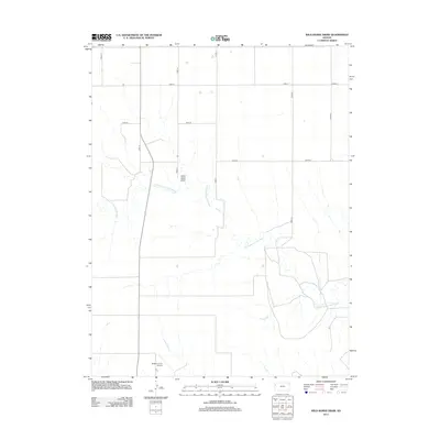
2012 Map of Wild Horse Draw
USGS Topo · Published 2012About this map
The N Fork Smoky Hill River carves a winding path through this portion of Wallace County, defining a landscape shaped by intermittent watercourses and expansive prairie. In this high plains environment, the eponymous Wild Horse Draw serves as a prominent natural drainage feature, cutting across the section lines that organize the rural landscape. The grid of country roads, including north-south corridors like Road 19 and Road 21, reflects the systematic land surveys that govern Kansas agriculture. A notable point of human activity in this sparsely settled region is the Bellamy Farm Airport, a private airstrip that highlights the importance of aerial access for large-scale ranching and farming operations in western Kansas. The map captures a moment of modern land use where traditional river-bottom topography meets the rigid geometry of the section-line road network.
Find a feature on this map
12 named features on this map. Tap any name to fly to it.
Don’t see what you’re looking for? This feature index may not catch every label — zoom into the map to look around manually.
Map Details
Editions of this 2012 Wild Horse Draw Map
This is the sole edition of this map. No revisions or reprints were ever made.
Other maps of this area

1954 · Goodland
USGS Topo · 1:250,000

1956 · Goodland
USGS Topo · 1:250,000

1957 · Goodland
USGS Topo · 1:250,000

1959 · Harris Draw
USGS Topo · 1:62,500

1959 · Horsethief Draw
USGS Topo · 1:62,500

1966 · Goodland
USGS Topo · 1:24,000

1966 · Edson
USGS Topo · 1:24,000
1966 · Ruleton SE
USGS Topo · 1:24,000
1979 · Harris Draw NE
USGS Topo · 1:24,000
1979 · Harris Draw East
USGS Topo · 1:24,000