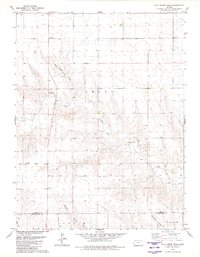
1979 Map of Wild Horse Draw
USGS Topo · Published 1980About this map
North Fork Smoky Hill River carves a winding path through the high plains at the boundary of Sherman and Wallace counties, defining the hydrologic character of this western Kansas landscape in the late 1970s. The map reveals a network of intermittent watercourses and deep-cut drainage features, most notably Wild Horse Draw and Kolacny Canyon, which demonstrate the erosional patterns of the Smoky Hill region. The sparse distribution of man-made structures is punctuated only by several industrial Gravel Pit locations and a series of scattered Wells, reflecting a rural economy tied closely to geological resources and agriculture. The convergence of Gardner Draw and other seasonal tributaries like Lake Cr into the larger river system highlights the critical role of these drainages in an otherwise arid environment.
Find a feature on this map
14 named features on this map. Tap any name to fly to it.
Don’t see what you’re looking for? This feature index may not catch every label — zoom into the map to look around manually.
Map Details
Editions of this 1979 Wild Horse Draw Map
This is the sole edition of this map. No revisions or reprints were ever made.
Other maps of this area

1954 · Goodland
USGS Topo · 1:250,000

1956 · Goodland
USGS Topo · 1:250,000

1957 · Goodland
USGS Topo · 1:250,000

1959 · Harris Draw
USGS Topo · 1:62,500

1959 · Horsethief Draw
USGS Topo · 1:62,500

1966 · Goodland
USGS Topo · 1:24,000

1966 · Edson
USGS Topo · 1:24,000
1966 · Ruleton SE
USGS Topo · 1:24,000
1979 · Harris Draw NE
USGS Topo · 1:24,000
1979 · Harris Draw East
USGS Topo · 1:24,000