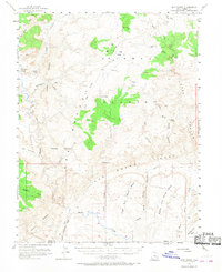
1952 Map of Wild Horse
USGS Topo · Published 1968About this map
The San Rafael Swell dominates this 1952 topographic study, revealing a complex network of canyons and mesas along the border of Emery and Wayne counties. The central drainage of Muddy Creek carves through the southern landscape, passing near the distinct Moroni Slopes and Segers Hole. Higher elevations are marked by landmarks like Tomsich Butte and the long, sharp ridge of The Reef that borders the Wild Horse Mesa complex.
Find a feature on this map
45 named features on this map. Tap any name to fly to it.
Don’t see what you’re looking for? This feature index may not catch every label — zoom into the map to look around manually.
Map Details
Editions of this 1952 Wild Horse Map
2 editions found
Other maps of this area

1885 · San Rafael
USGS Topo · 1:250,000

1885 · Fish Lake
USGS Topo · 1:250,000

1896 · Fish Lake
USGS Topo · 1:250,000

1952 · Wild Horse
USGS Topo · 1:62,500

1952 · San Rafael Knob
USGS Topo · 1:62,500

1953 · Stinking Spring Creek 2 SE
USGS Topo · 1:24,000

1953 · Emery 4 NE
USGS Topo · 1:24,000

1953 · Emery 4 SE
USGS Topo · 1:24,000

1953 · Emery 1 SE
USGS Topo · 1:24,000

1953 · Temple Mtn
USGS Topo · 1:62,500