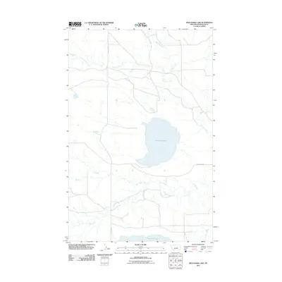
2011 Map of Wild Horse Lake
USGS Topo · Published 2011About this map
Wild Horse Lake and the smaller War Horse Lake define this prairie landscape in Petroleum County, serving as vital hydrologic markers in an arid region. The drainage patterns of central Montana are clearly visible through the winding courses of Box Elder Creek to the north and the multi-branched Fords Creek to the south. Human activity is centered on a sparse grid of rural arteries, such as Blakeslee Rd and Welter Divide Rd, which navigate the subtle divides between seasonal watercourses. This 2011 survey documents the persistent character of the high plains, where the land is partitioned by the South Fork Bear Creek and Duck Creek, reflecting a continuity of ranching and land use in one of the most sparsely populated corners of the state.
Find a feature on this map
8 named features on this map. Tap any name to fly to it.
Don’t see what you’re looking for? This feature index may not catch every label — zoom into the map to look around manually.
Map Details
Editions of this 2011 Wild Horse Lake Map
This is the sole edition of this map. No revisions or reprints were ever made.
Other maps of this area

1954 · Lewistown
USGS Topo · 1:250,000

1959 · Lewistown
USGS Topo · 1:250,000

1985 · Bear Creek Reservoir SE
USGS Topo · 1:24,000

1985 · Valentine
USGS Topo · 1:24,000
1985 · Bear Creek Reservoir
USGS Topo · 1:24,000

1986 · Wild Horse Lake
USGS Topo · 1:24,000

1986 · Briggs Coulee
USGS Topo · 1:24,000

1986 · Dry Blood Creek West
USGS Topo · 1:24,000

1986 · Teigen NW
USGS Topo · 1:24,000

1986 · Teigen
USGS Topo · 1:24,000