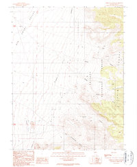
1989 Map of Wildcat Canyon
USGS Topo · Published 1990About this map
Big Smoky Valley dominates the western portion of this landscape, where the alluvial fans meet the steep rise of the Toquima Range. This late 1980s landscape is defined by its transition from the valley floor to the high elevations of the Toiyabe National Forest. Evidence of local mineral exploration and industry is visible near the valley edge, specifically marked by tailings and a landing strip, indicating the logistical infrastructure required for remote operations. Higher in the canyons, multiple prospects are noted, while named water sources like Iron Spring and Jeans Spring provide critical points of interest in this arid environment. The map details the complex drainage patterns of Wildcat Canyon and West Northumberland Canyon, as well as the distinctive Hoodoo formation, offering a clear record of the area's geological and industrial character during this period of field survey.
Find a feature on this map
25 named features on this map. Tap any name to fly to it.
Don’t see what you’re looking for? This feature index may not catch every label — zoom into the map to look around manually.
Map Details
Editions of this 1989 Wildcat Canyon Map
This is the sole edition of this map. No revisions or reprints were ever made.
Other maps of this area

1907 · Tonopah
USGS Topo · 1:250,000

1908 · Tonopah
USGS Topo · 1:250,000

1926 · Roberts Mountains
USGS Topo · 1:250,000

1929 · Roberts Mountains
USGS Topo · 1:250,000

1955 · Millett
USGS Topo · 1:250,000

1956 · Millett Ranch
USGS Topo · 1:62,500

1956 · Tonopah
USGS Topo · 1:250,000

1959 · Tonopah
USGS Topo · 1:250,000

1959 · Millett
USGS Topo · 1:250,000

1960 · Wildcat Peak
USGS Topo · 1:62,500