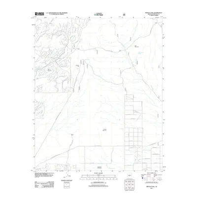
2011 Map of Wildcat Hill
USGS Topo · Published 2011About this map
Browns Ranch serves as a focal point in this desert landscape, where the Sonoran environment meets a growing network of residential infrastructure and recreation. The terrain is defined by prominent peaks including Wildcat Hill, Blue Mountain, Granite Mountain, and Fraesfield Mountain. To the west, the Desert Mountain Golf Course signals modern development, while water resources such as Wildcat Tank, Blue Mountain Spring, and Bootlegger Tank indicate the historical reliance on catchment and springs in this arid climate. The landscape is carved by drainage systems like Galloway Wash and Camp Creek, which dictate the placement of local roads. Significant utilities cross the area, including the Four Corners Power Line Rd and Pinnacle Peak Power Line Rd, marking the corridor for regional energy transmission north of the Scottsdale area.
Find a feature on this map
42 named features on this map. Tap any name to fly to it.
Don’t see what you’re looking for? This feature index may not catch every label — zoom into the map to look around manually.
Map Details
Editions of this 2011 Wildcat Hill Map
This is the sole edition of this map. No revisions or reprints were ever made.
Other maps of this area

1904 · Camelback
USGS Topo · 1:62,500

1904 · Ft. McDowell
USGS Topo · 1:62,500

1906 · Camelsback
USGS Topo · 1:62,500

1906 · Ft. McDowell
USGS Topo · 1:62,500

1930 · Cave Creek
USGS Topo · 1:125,000

1939 · Cave Creek
USGS Topo · 1:125,000

1954 · Mesa
USGS Topo · 1:250,000

1957 · Mesa
USGS Topo · 1:250,000

1958 · Mesa
USGS Topo · 1:250,000

1960 · Mesa
USGS Topo · 1:250,000