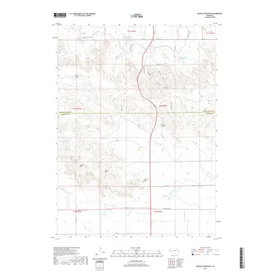
2017 Map of Wildcat Mountain
USGS Topo · Published 2017About this map
Wildcat Mtn and the neighboring Hogback Mtn anchor the high ground along the border of Scotts Bluff and Banner counties. This modern survey illustrates the complex drainage and irrigation systems essential to the Nebraska Panhandle, including the Fort Laramie Canal and multiple storage facilities like Gering Valley Reservoir A. The landscape is defined by the sharp transition between the upland Wildcat Hills and the valley floor where Pumpkin Cr flows. A network of rural routes, such as Old Stage Hill Rd and Peaceful Valley Rd, connects isolated topographic landmarks like Funnel Rock and Dooley Canyon. The map reveals the modern infrastructure overlaid on a terrain shaped by erosion and water management, providing a clear view of the area's rural development and geographic character.
Find a feature on this map
35 named features on this map. Tap any name to fly to it.
Don’t see what you’re looking for? This feature index may not catch every label — zoom into the map to look around manually.
Map Details
Editions of this 2017 Wildcat Mountain Map
This is the sole edition of this map. No revisions or reprints were ever made.
Other maps of this area

1898 · Scotts Bluff
USGS Topo · 1:125,000

1954 · Scottsbluff
USGS Topo · 1:250,000

1958 · Scottsbluff
USGS Topo · 1:250,000

1963 · Scottsbluff South
USGS Topo · 1:24,000

1963 · Roubadeau Pass
USGS Topo · 1:24,000

1965 · Minatare
USGS Topo · 1:24,000

1973 · Scotts Bluff 4 NW
USGS Topo · 1:24,000

1973 · Scotts Bluff 4 SE
USGS Topo · 1:24,000

1973 · Scotts Bluff 4 NE
USGS Topo · 1:24,000

1973 · Scotts Bluff 4 SW
USGS Topo · 1:24,000