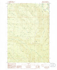
1985 Map of Wildcat Mountain
USGS Topo · Published 1986About this map
Mt Hood National Forest dominates this mid-1980s survey, illustrating a landscape defined by sharp ridges and a complex network of tributaries. The Salmon River flows through the northeastern corner, near a local Trailer Park, while the rest of the quadrangle is characterized by significant elevations including Wildcat Mtn, Huckleberry Mtn, and the distinctive Old Baldy.
Find a feature on this map
28 named features on this map. Tap any name to fly to it.
Don’t see what you’re looking for? This feature index may not catch every label — zoom into the map to look around manually.
Map Details
Editions of this 1985 Wildcat Mountain Map
This is the sole edition of this map. No revisions or reprints were ever made.
Other maps of this area

1916 · Estacada
USGS Topo · 1:125,000

1924 · Mount Hood
USGS Topo · 1:125,000

1927 · Mount Hood
USGS Topo · 1:125,000

1948 · Vancouver
USGS Topo · 1:250,000

1950 · Vancouver
USGS Topo · 1:250,000

1950 · Vancouver
USGS Topo · 1:250,000

1953 · The Dalles
USGS Topo · 1:250,000

1955 · Cherryville
USGS Topo · 1:62,500

1956 · The Dalles
USGS Topo · 1:250,000

1956 · Fish Creek Mtn
USGS Topo · 1:62,500