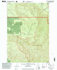
1997 Map of Wildcat Mountain
USGS Topo · Published 1999About this map
Mt Hood National Forest dominates this landscape, showing a transition from managed forest land to the protected reaches of the Salmon - Huckleberry Wilderness. The drainage network is particularly dense here, with the Salmon River and Sandy River converging in the northeast corner near a Mobile Home Park. Higher elevations are defined by prominent peaks including Wildcat Mtn, Huckleberry Mtn, and Old Baldy, which are separated by deep drainages like Boulder Creek and North Fork Eagle Creek. The map reflects a landscape primarily utilized for recreation and resource extraction, evidenced by Coffman Camp and the Wildcat Gravel Pit. Structural features like Mc Intyre Ridge dictate the flow of numerous tributaries, including Cheeney Creek and Alder Creek, illustrating the complex hydrology of the Oregon Cascades.
Find a feature on this map
26 named features on this map. Tap any name to fly to it.
Don’t see what you’re looking for? This feature index may not catch every label — zoom into the map to look around manually.
Map Details
Editions of this 1997 Wildcat Mountain Map
This is the sole edition of this map. No revisions or reprints were ever made.
Other maps of this area

1916 · Estacada
USGS Topo · 1:125,000

1924 · Mount Hood
USGS Topo · 1:125,000

1927 · Mount Hood
USGS Topo · 1:125,000

1948 · Vancouver
USGS Topo · 1:250,000

1950 · Vancouver
USGS Topo · 1:250,000

1950 · Vancouver
USGS Topo · 1:250,000

1953 · The Dalles
USGS Topo · 1:250,000

1955 · Cherryville
USGS Topo · 1:62,500

1956 · The Dalles
USGS Topo · 1:250,000

1956 · Fish Creek Mtn
USGS Topo · 1:62,500