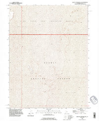
1993 Map of Wildcat Mountain SW
USGS Topo · Published 1996About this map
Dugway Proving Ground dominates this 1993 landscape, illustrating the immense scale of military operations in the Great Salt Lake Desert. The terrain is characterized by extensive, level stretches of Mud Flat, where the lack of vertical relief and vegetation made the area ideal for specialized testing and maneuvers. This section of the Utah Test and Training Range shows the intersection of several townships, including T 5 S, T 6 S, and T 7 S, though the land remains largely devoid of permanent civilian settlement or commercial infrastructure. The map serves as a record of mid-to-late 20th-century military land use, where the desolate environment of Tooele County was leveraged for strategic defense purposes during the Cold War era.
Find a feature on this map
6 named features on this map. Tap any name to fly to it.
Don’t see what you’re looking for? This feature index may not catch every label — zoom into the map to look around manually.
Map Details
Editions of this 1993 Wildcat Mountain SW Map
This is the sole edition of this map. No revisions or reprints were ever made.
Other maps of this area

1953 · Tooele
USGS Topo · 1:250,000

1954 · Wildcat Mtn
USGS Topo · 1:24,000

1954 · Granite Peak
USGS Topo · 1:24,000

1954 · Wildcat Mtn SE
USGS Topo · 1:24,000

1955 · Tooele
USGS Topo · 1:250,000

1973 · Wildcat Mountain SW
USGS Topo · 1:24,000

1973 · Wildcat Mountain NW
USGS Topo · 1:24,000

1973 · Gold Hill 1 SE
USGS Topo · 1:24,000

1973 · Gold Hill 1 NE
USGS Topo · 1:24,000

1973 · Granite Peak NW
USGS Topo · 1:24,000