
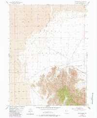
1954 Map of Granite Peak
USGS Topo · Published 1956About this map
Granite Peak rises as a prominent landmark in the high desert of Tooele County, serving as the focal point for this mid-1950s survey. The landscape is defined by its role in Cold War military operations, with the Wendover Bombing and Gunnery Range and Dugway Proving Ground intersecting here. The map documents specialized infrastructure of the era, including a dedicated Landing Strip and the Gpi-2 site located at the northern edge of the peak's rising terrain. Transportation across this restricted area is limited to a handful of gravel and unimproved routes, such as Goodyear Road, Stark Road, and Falconer Road. The presence of Gravel Pits and a solitary Spring near the mountainside highlights the sparse resources found in this part of the Great Salt Lake Desert during a period of intense military testing and expansion.
Find a feature on this map
10 named features on this map. Tap any name to fly to it.
Don’t see what you’re looking for? This feature index may not catch every label — zoom into the map to look around manually.
Map Details
Editions of this 1954 Granite Peak Map
2 editions found
Other maps of this area

1953 · Tooele
USGS Topo · 1:250,000

1954 · Wig Mtn SW
USGS Topo · 1:24,000

1954 · Dugway Proving Ground SW
USGS Topo · 1:24,000

1954 · Wildcat Mtn SE
USGS Topo · 1:24,000

1954 · Dugway Proving Ground NW
USGS Topo · 1:24,000

1954 · Granite Peak SE
USGS Topo · 1:24,000

1955 · Tooele
USGS Topo · 1:250,000

1973 · Wildcat Mountain SW
USGS Topo · 1:24,000

1973 · Granite Peak NW
USGS Topo · 1:24,000
1973 · Granite Peak SW
USGS Topo · 1:24,000