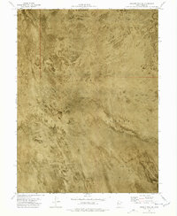
1973 Map of Granite Peak SW
USGS Topo · Published 1977About this map
Dugway Proving Ground dominates this 1970s orthophotomap, showing the stark, expansive landscape of the Great Salt Lake Desert. The terrain is characterized by a nearly featureless Mud Flat, where the orthophotomosaic technique reveals the subtle textures of the dry lake bed that traditional contour lines alone might miss. This military installation, established during World War II, remains one of the most secluded and controlled environments in the United States. The map's minimalist detail reflects the geographic isolation of the region, emphasizing the vast, open stretches of alkali flats and the absence of civilian settlements or infrastructure within this restricted high-desert corridor.
Find a feature on this map
4 named features on this map. Tap any name to fly to it.
Don’t see what you’re looking for? This feature index may not catch every label — zoom into the map to look around manually.
Map Details
Editions of this 1973 Granite Peak SW Map
2 editions found
Other maps of this area

1908 · Fish Springs
USGS Topo · 1:250,000

1910 · Fish Springs
USGS Topo · 1:250,000

1953 · Tooele
USGS Topo · 1:250,000

1953 · Delta
USGS Topo · 1:250,000

1954 · Granite Peak
USGS Topo · 1:24,000

1954 · Granite Peak SE
USGS Topo · 1:24,000

1955 · Tooele
USGS Topo · 1:250,000

1958 · Delta
USGS Topo · 1:250,000

1962 · Delta
USGS Topo · 1:250,000

1967 · Fish Springs NW
USGS Topo · 1:24,000