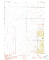
1989 Map of Wildcat Peak NW
USGS Topo · Published 1990About this map
Big Smoky Valley dominates the western half of this 1980s landscape, a broad expanse defined by water management and transit routes across the high desert. The map captures a transition from the level basin floor to the steep eastern elevations of the Toquima Range. Within these mountains, the Toiyabe National Forest boundary protects a rugged area marked by Clipper Gap Canyon. Human presence is primarily indicated by utilitarian features necessary for ranching and infrastructure in a demanding environment, including Alkali Flat Well, Triple T Well, and a long Ditch cutting through the valley. These scattered water sources and a network of 4wd tracks and a Trans Line illustrate how the border between Lander Co and Nye Co was navigated and utilized in the late twentieth century.
Find a feature on this map
11 named features on this map. Tap any name to fly to it.
Don’t see what you’re looking for? This feature index may not catch every label — zoom into the map to look around manually.
Map Details
Editions of this 1989 Wildcat Peak NW Map
This is the sole edition of this map. No revisions or reprints were ever made.
Other maps of this area

1926 · Roberts Mountains
USGS Topo · 1:250,000

1929 · Roberts Mountains
USGS Topo · 1:250,000

1955 · Millett
USGS Topo · 1:250,000

1956 · Millett Ranch
USGS Topo · 1:62,500

1956 · Austin
USGS Topo · 1:62,500

1959 · Millett
USGS Topo · 1:250,000

1960 · Spencer Hot Springs
USGS Topo · 1:62,500

1960 · Wildcat Peak
USGS Topo · 1:62,500

1978 · Summit Mountain
USGS Topo · 1:100,000

1985 · Smith Creek Valley
USGS Topo · 1:100,000