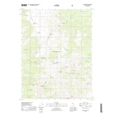
2018 Map of Wildcat Peak
USGS Topo · Published 2018About this map
The high ridges of the Toquima Range dominate this interior portion of the Toiyabe National Forest, where steep canyons and significant vertical relief define the Great Basin landscape. Water sources like Copper Mine Spring and Wildcat Spring appear as critical markers in an otherwise arid environment, suggesting the historical importance of these spots for both early mining prospects and livestock management.
Find a feature on this map
45 named features on this map. Tap any name to fly to it.
Don’t see what you’re looking for? This feature index may not catch every label — zoom into the map to look around manually.
Map Details
Editions of this 2018 Wildcat Peak Map
This is the sole edition of this map. No revisions or reprints were ever made.
Other maps of this area

1926 · Roberts Mountains
USGS Topo · 1:250,000

1929 · Roberts Mountains
USGS Topo · 1:250,000

1955 · Millett
USGS Topo · 1:250,000

1956 · Tonopah
USGS Topo · 1:250,000

1959 · Tonopah
USGS Topo · 1:250,000

1959 · Millett
USGS Topo · 1:250,000

1960 · Dianas Punch Bowl
USGS Topo · 1:62,500

1960 · Wildcat Peak
USGS Topo · 1:62,500

1962 · Tonopah
USGS Topo · 1:250,000
1971 · Jet Spring
USGS Topo · 1:24,000