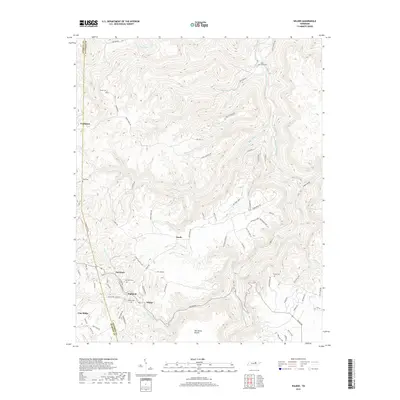
2019 Map of Wilder
USGS Topo · Published 2019About this map
The East Fork Obey River carves a deep valley through this portion of the Cumberland Plateau, anchoring a landscape where small settlements like Wilder and Highland follow the ridgelines and creek beds. This 2019 survey captures the geographic legacy of the region's historical coal and timber settlements, tracing the boundary between Overton and Fentress counties. The density of family and community burial grounds, such as Wilder Cem, Davidson Cem, and Bills Creek Cem, speaks to the deep-rooted genealogical history of the area. Rugged terrain features like The Horse Pound and Lints Cove are surrounded by a web of rural routes, including Wilder Rd and Wilson Ridge Rd. The map provides a detailed look at the scattered residential clusters of Davidson, Cooktown, and Vine Ridge as they appeared in the early 21st century, linked by narrow hollows and numerous watercourses like Big Piney Cr and Big Laurel Cr.
Find a feature on this map
85 named features on this map. Tap any name to fly to it.
Don’t see what you’re looking for? This feature index may not catch every label — zoom into the map to look around manually.
Map Details
Editions of this 2019 Wilder Map
This is the sole edition of this map. No revisions or reprints were ever made.
Other maps of this area

1895 · Wartburg
USGS Topo · 1:125,000

1896 · Wartburg
USGS Topo · 1:125,000

1897 · Standingstone
USGS Topo · 1:125,000

1898 · Standingstone
USGS Topo · 1:125,000

1935 · Clarkrange
USGS Topo · 1:24,000

1936 · Jones Knob
USGS Topo · 1:24,000

1946 · Clarkrange
USGS Topo · 1:24,000

1946 · Obey City
USGS Topo · 1:24,000
1949 · Jones Knob
USGS Topo · 1:24,000
1950 · Clarkrange
USGS Topo · 1:24,000