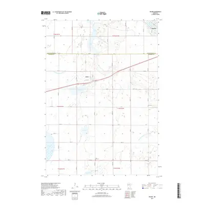
2019 Map of Wilder
USGS Topo · Published 2019About this map
Wilder and the southwestern edge of Windom anchor this rural landscape along the border of Cottonwood and Jackson Counties. The terrain is defined by a dense network of glacial wetlands and water bodies, including Timber Lake, Teal Lake, and the expansive Heron Lake to the southwest. The Des Moines River cuts through the northeastern corner, providing a natural contrast to the numerous engineered watercourses such as Judicial Ditch Number Fiftyfour and Judicial Ditch Number Twentyseven. These ditches represent a significant effort to manage the prairie hydrology for agricultural use. For those researching local history or genealogy, the map identifies several rural burial sites, including Wilder Cem, Delafield Cem, Saint Peter Cem, and Brill Cem. The section-line road system, including routes like Co Hwy 18 and Co Hwy 4, illustrates the enduring structure of the Public Land Survey System in southern Minnesota.
Find a feature on this map
52 named features on this map. Tap any name to fly to it.
Don’t see what you’re looking for? This feature index may not catch every label — zoom into the map to look around manually.
Map Details
Editions of this 2019 Wilder Map
This is the sole edition of this map. No revisions or reprints were ever made.
Other maps of this area

1954 · Fairmont
USGS Topo · 1:250,000

1958 · Fairmont
USGS Topo · 1:250,000

1960 · Okabena
USGS Topo · 1:24,000

1970 · Lakefield NE
USGS Topo · 1:24,000
1970 · Bingham Lake
USGS Topo · 1:24,000
1970 · Harder Lake
USGS Topo · 1:24,000

1970 · Wilder
USGS Topo · 1:24,000

1970 · Lakefield
USGS Topo · 1:24,000

1970 · Windom
USGS Topo · 1:24,000
1970 · Heron Lake NE
USGS Topo · 1:24,000