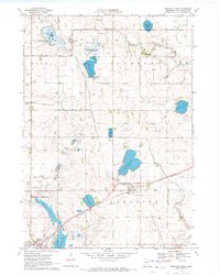
1970 Map of Bingham Lake
USGS Topo · Published 1972About this map
Bingham Lake and the nearby unincorporated community of Delft are central to this 1970 landscape in Cottonwood County. The geography is defined by a dense concentration of glacial prairie potholes and larger water bodies like Eagle Lake, Maiden Lake, and Clear Lake, which support the regional conservation efforts visible at the Little Swan Lake State Wildlife Management Area. The Chicago and North Western railroad provides the primary industrial artery, cutting diagonally through the terrain to connect these agricultural hubs. In the southwest, the edge of Windom appears alongside the Windom Municipal Airport. Local genealogy is well-documented through several burial sites, including Delft Cem, Voth Cem, and Resthaven Memory Gardens, while the Watonwan River meanders across the northern sections, tracing the natural drainage of this productive lake-dotted plains region.
Find a feature on this map
26 named features on this map. Tap any name to fly to it.
Don’t see what you’re looking for? This feature index may not catch every label — zoom into the map to look around manually.
Map Details
Editions of this 1970 Bingham Lake Map
This is the sole edition of this map. No revisions or reprints were ever made.
Other maps of this area

1953 · New Ulm
USGS Topo · 1:250,000

1954 · Fairmont
USGS Topo · 1:250,000

1957 · New Ulm
USGS Topo · 1:250,000

1958 · New Ulm
USGS Topo · 1:250,000

1958 · Fairmont
USGS Topo · 1:250,000

1967 · New Ulm
USGS Topo · 1:250,000

1967 · Sanborn SE
USGS Topo · 1:24,000

1967 · Jeffers
USGS Topo · 1:24,000
1967 · Comfrey
USGS Topo · 1:24,000
1970 · Harder Lake
USGS Topo · 1:24,000