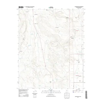
2013 Map of Wildhorse Mesa
USGS Topo · Published 2013About this map
Wildhorse Mesa and the elevated plateau of Pine Mesa define this high-altitude landscape in Santa Fe County, where life revolves around water management in a drainage-carved terrain. The map reveals a network of canyons including Pine Canyon, Tarhole Canyon, and Buckhorn Canyon, all feeding into seasonal watercourses such as Arroyo Jara and Arroyo Jaspe. Local habitation is concentrated at sites like Young Place and Dyer Ranch, supported by a high density of specialized water features. Numerous cattle tanks, such as Estracada Tank Number 1, Horse Pasture Tank, and King Tank, illustrate the reliance on collected runoff for ranching. Natural water sources like Cañoncito Spring and The Seep punctuate the landscape, while the presence of Rock Quarry Tank suggests local mineral extraction or road-building activities in this corner of New Mexico.
Find a feature on this map
34 named features on this map. Tap any name to fly to it.
Don’t see what you’re looking for? This feature index may not catch every label — zoom into the map to look around manually.
Map Details
Editions of this 2013 Wildhorse Mesa Map
This is the sole edition of this map. No revisions or reprints were ever made.
Other maps of this area

1894 · Lamy
USGS Topo · 1:125,000

1954 · Santa Fe
USGS Topo · 1:250,000

1958 · Santa Fe
USGS Topo · 1:250,000

1960 · Stanley
USGS Topo · 1:62,500
1966 · Mesa El Toro
USGS Topo · 1:24,000
1966 · Ojo Hedionda
USGS Topo · 1:24,000
1966 · Galisteo
USGS Topo · 1:24,000
1966 · Rencona
USGS Topo · 1:24,000
1966 · Bull Canyon
USGS Topo · 1:24,000
1966 · Wildhorse Mesa
USGS Topo · 1:24,000