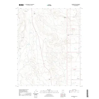
2020 Map of Wildhorse Mesa
USGS Topo · Published 2020About this map
Wildhorse Mesa and Pine Mesa dominate this high-altitude landscape in Santa Fe County, where water management is the primary signature of land use. The terrain is deeply incised by numerous drainages, including Tarhole Canyon, Hub Canyon, and Buckhorn Canyon, which feed into the central Cañada Estacada. Scattered throughout the high desert are essential water features such as The Seep, Cañoncito Spring, and a complex network of tanks like Estracada Tank Number 1, Comanche Tank, and Rock Quarry Tank. This concentration of catchment infrastructure reflects the historical necessity of securing water for livestock and local habitation in an arid environment. The map also traces the winding routes of local thoroughfares including Ojo De La Vaca Rd and Co Rd 34, providing a clear record of the modern road network navigating the bluffs and arroyos.
Find a feature on this map
31 named features on this map. Tap any name to fly to it.
Don’t see what you’re looking for? This feature index may not catch every label — zoom into the map to look around manually.
Map Details
Editions of this 2020 Wildhorse Mesa Map
This is the sole edition of this map. No revisions or reprints were ever made.
Other maps of this area

1894 · Lamy
USGS Topo · 1:125,000

1954 · Santa Fe
USGS Topo · 1:250,000

1958 · Santa Fe
USGS Topo · 1:250,000

1960 · Stanley
USGS Topo · 1:62,500
1966 · Mesa El Toro
USGS Topo · 1:24,000
1966 · Ojo Hedionda
USGS Topo · 1:24,000
1966 · Galisteo
USGS Topo · 1:24,000
1966 · Rencona
USGS Topo · 1:24,000
1966 · Bull Canyon
USGS Topo · 1:24,000
1966 · Wildhorse Mesa
USGS Topo · 1:24,000