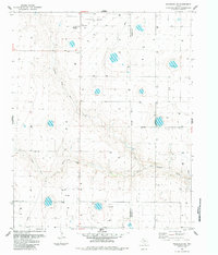
1984 Map of Wildorado SW
USGS Topo · Published 1984About this map
Palo Duro sits at the heart of this High Plains landscape, where the agricultural and industrial infrastructure of the Texas Panhandle is clearly documented. The map identifies key local landmarks essential for genealogical research, such as the Palo Duro Wildorado Cemetery, and markers of the mid-20th-century economy like a grain Elevator and a Landing Strip. The terrain is defined by the winding course of North Palo Duro Creek, which cuts through the topography alongside modern utility features including a large Pipeline and an Aqueduct. This 1984 revision also notes the boundary between Deaf Smith and Randall Counties, providing a clear record of land use and civil division in this prairie region.
Find a feature on this map
9 named features on this map. Tap any name to fly to it.
Don’t see what you’re looking for? This feature index may not catch every label — zoom into the map to look around manually.
Map Details
Editions of this 1984 Wildorado SW Map
This is the sole edition of this map. No revisions or reprints were ever made.
Other maps of this area

1954 · Tucumcari
USGS Topo · 1:250,000

1954 · Clovis
USGS Topo · 1:250,000

1958 · Clovis
USGS Topo · 1:250,000

1958 · Tucumcari
USGS Topo · 1:250,000

1961 · Buffalo Lake
USGS Topo · 1:62,500

1962 · Wildorado
USGS Topo · 1:62,500

1965 · Everett
USGS Topo · 1:24,000

1965 · Allison Ranch
USGS Topo · 1:24,000

1971 · Hereford NE
USGS Topo · 1:24,000
1984 · Bivins Lake
USGS Topo · 1:24,000