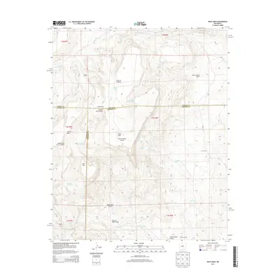
2013 Map of Wiley Mesa
USGS Topo · Published 2013About this map
Manning Cabin stands as a lonely outpost in this arid landscape where the borders of Cibola, Catron, and Socorro counties converge. This high-desert terrain is defined by a network of drainage systems and watering points essential for ranching, including the Rincon Windmill and Saddle Windmill. The topography is dominated by the massive Wiley Mesa and Techado Mesa, while deep erosional features like Cañon de la Mosca and Willow Springs Canyon carve through the plateau. In the southern portion of the quadrangle, Kicking Bear Wash feeds into the Rio Salado, illustrating the complex watershed of the New Mexico interior. The distribution of features like Wiley Lake and various tanks suggests a landscape focused on resource management in a region where water is the most precious commodity.
Find a feature on this map
37 named features on this map. Tap any name to fly to it.
Don’t see what you’re looking for? This feature index may not catch every label — zoom into the map to look around manually.
Map Details
Editions of this 2013 Wiley Mesa Map
This is the sole edition of this map. No revisions or reprints were ever made.
Other maps of this area

1917 · Broom Mountain
USGS Topo · 1:125,000

1954 · Socorro
USGS Topo · 1:250,000

1958 · Socorro
USGS Topo · 1:250,000

1962 · Socorro
USGS Topo · 1:250,000
1964 · Cebollita Peak
USGS Topo · 1:24,000

1964 · Table Mountain
USGS Topo · 1:24,000

1964 · Wiley Mesa
USGS Topo · 1:24,000

1964 · Pasture Canyon
USGS Topo · 1:24,000
1964 · Mecate Meadow
USGS Topo · 1:24,000
1964 · Wild Horse Canyon
USGS Topo · 1:24,000