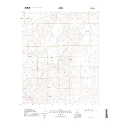
2020 Map of Wiley Mesa
USGS Topo · Published 2020About this map
Wiley Mesa dominates this corner of the High Desert where the borders of Cibola, Catron, and Socorro counties converge. The landscape is defined by massive landforms like Techado Mesa and Mid Mesa, carved by deep drainage systems such as Middle Mesa Canyon and Painted Rock Canyon. Water sources are vital markers in this arid environment, ranging from the springs at Ojo de la Mosca and Willow Spring to isolated catchments like Wedding Tank and Latta Tanks. To the south, the terrain descends toward the Rio Salado and the curiously named Kicking Bear Wash. The network of simple tracks, including Mertz and Merch Rd, underscores the remote nature of this ranching and grazing land as it was documented by the Geological Survey in the early twenty-first century.
Find a feature on this map
34 named features on this map. Tap any name to fly to it.
Don’t see what you’re looking for? This feature index may not catch every label — zoom into the map to look around manually.
Map Details
Editions of this 2020 Wiley Mesa Map
This is the sole edition of this map. No revisions or reprints were ever made.
Other maps of this area

1917 · Broom Mountain
USGS Topo · 1:125,000

1954 · Socorro
USGS Topo · 1:250,000

1958 · Socorro
USGS Topo · 1:250,000

1962 · Socorro
USGS Topo · 1:250,000
1964 · Cebollita Peak
USGS Topo · 1:24,000

1964 · Table Mountain
USGS Topo · 1:24,000

1964 · Wiley Mesa
USGS Topo · 1:24,000

1964 · Pasture Canyon
USGS Topo · 1:24,000
1964 · Mecate Meadow
USGS Topo · 1:24,000
1964 · Wild Horse Canyon
USGS Topo · 1:24,000