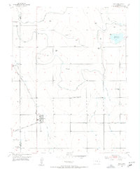
1955 Map of Wiley
USGS Topo · Published 1956About this map
Agricultural development in the Arkansas River Valley is meticulously documented on this mid-century survey of Wiley and the surrounding plains. The landscape is defined by an intricate network of irrigation infrastructure, including the Fort Lyon Canal, Pawnee Canal, and various water management systems like the Wiley Drainage Ditch and Marburg Ditch. These waterways support the local economy alongside the Atchison Topeka and Santa Fe railroad, which bisects the territory.
Find a feature on this map
22 named features on this map. Tap any name to fly to it.
Don’t see what you’re looking for? This feature index may not catch every label — zoom into the map to look around manually.
Map Details
Editions of this 1955 Wiley Map
2 editions found
Other maps of this area

1892 · Lamar
USGS Topo · 1:125,000

1952 · Lamar West
USGS Topo · 1:24,000

1953 · Lamar East
USGS Topo · 1:24,000

1953 · Prowers
USGS Topo · 1:24,000

1954 · Lamar
USGS Topo · 1:250,000

1955 · McClave
USGS Topo · 1:24,000

1955 · May Valley
USGS Topo · 1:24,000

1955 · Wiley
USGS Topo · 1:24,000

1958 · Lamar
USGS Topo · 1:250,000

1967 · Neenoshe Reservoir
USGS Topo · 1:24,000