
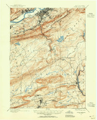
1891 Map of Wilkesbarre
USGS Topo · Published 1891About this map
The Susquehanna River corridor anchors this late 19th-century study, showcasing the dense industrial and rail infrastructure of the Wyoming Valley. Major hubs like Wilkesbarre, Plymouth, and Nanticoke are linked by a complex web of railroads, including the Bloomsburg Division and Lehigh Valley R. R.. The map reveals the region's coal-driven development through smaller mining settlements and company patches such as Moffatt Patch and Sugar Notch.
Find a feature on this map
88 named features on this map. Tap any name to fly to it.
Don’t see what you’re looking for? This feature index may not catch every label — zoom into the map to look around manually.
Map Details
Editions of this 1891 Wilkesbarre Map
2 editions found
Other maps of this area

1889 · Scranton
USGS Topo · 1:62,500

1889 · Hazleton
USGS Topo · 1:62,500

1891 · Hazleton
USGS Topo · 1:62,500

1891 · Scranton
USGS Topo · 1:62,500

1891 · Harveys Lake
USGS Topo · 1:62,500

1892 · Mahanoy
USGS Topo · 1:62,500

1893 · Hazleton
USGS Topo · 1:62,500

1893 · Harvey Lake
USGS Topo · 1:62,500

1893 · Pittston
USGS Topo · 1:62,500

1893 · Scranton
USGS Topo · 1:62,500