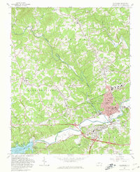
1966 Map of Wilkesboro
USGS Topo · Published 1981About this map
The confluence of the Reddies River and the Yadkin River anchors this 1960s survey of the Foothills region, showing the dual centers of North Wilkesboro and Wilkesboro. To the southwest, the W Kerr Scott Dam holds back the massive W Kerr Scott Reservoir, a primary geographical feature that altered the local landscape. The map details a dense network of rural life, including community hubs like Cricket and Millers Creek, alongside numerous neighborhood spiritual centers such as Harmony Ch and Welcome Home Ch. Local infrastructure is well-represented by the County Airport and Wilkes Central High Sch, while specialized landmarks like the Drive-in Theater and Radio Tower (WKBC) reflect the mid-century cultural footprint of the area.
Find a feature on this map
73 named features on this map. Tap any name to fly to it.
Don’t see what you’re looking for? This feature index may not catch every label — zoom into the map to look around manually.
Map Details
Editions of this 1966 Wilkesboro Map
2 editions found
Other maps of this area

1889 · Wilkesboro
USGS Topo · 1:125,000

1891 · Wilkesboro
USGS Topo · 1:125,000

1953 · Winston-Salem
USGS Topo · 1:250,000

1955 · Winston-Salem
USGS Topo · 1:250,000

1962 · Winston-Salem
USGS Topo · 1:250,000
1966 · Gilreath
USGS Topo · 1:24,000

1966 · Roaring River
USGS Topo · 1:24,000
1966 · Boomer
USGS Topo · 1:24,000
1966 · Moravian Falls
USGS Topo · 1:24,000

1966 · Wilkesboro
USGS Topo · 1:24,000