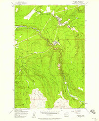
1956 Map of Wilkeson
USGS Topo · Published 1958About this map
The Northern Pacific railroad winds through the coal and timber country of Pierce County, connecting the industrial settlements of Wilkeson and Carbonado. This mid-century survey reveals a landscape defined by resource extraction and elevation, where numerous tunnels and prospects mark the steep slopes above the Carbon River. The map captures the tight-knit grid of company towns alongside family-named geography like Brooks Hill and Gleason Hill. Southward, the terrain climbs toward the high ridges and glacial runoff of the Cascades, where the Electron Lookout stands watch over the drainage basins of Voight Creek and Mowich Lake. Small upland communities like Fairfax and Upper Fairfax are shown at the edge of the wilderness, linked by narrow routes such as Fairfax Road as the valley narrows toward the mountain.
Find a feature on this map
46 named features on this map. Tap any name to fly to it.
Don’t see what you’re looking for? This feature index may not catch every label — zoom into the map to look around manually.
Map Details
Editions of this 1956 Wilkeson Map
3 editions found
Other maps of this area

1897 · Tacoma
USGS Topo · 1:125,000

1900 · Tacoma
USGS Topo · 1:125,000

1913 · Cedar Lake
USGS Topo · 1:125,000

1924 · Mt Rainier
USGS Topo · 1:96,000

1928 · Mt Rainier
USGS Topo · 1:125,000

1937 · Eatonville
USGS Topo · 1:125,000

1942 · Lake Tapps
USGS Topo · 1:62,500

1944 · Lake Tapps
USGS Topo · 1:62,500

1950 · Yakima
USGS Topo · 1:250,000

1953 · Hoquiam
USGS Topo · 1:250,000