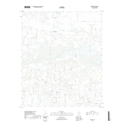
2019 Map of Wilkinson
USGS Topo · Published 2019About this map
White Oak Creek and its broad, marshy floodplain dominate the central geography of this portion of Titus County, creating a natural barrier between the northern and southern settlements. Small agricultural communities such as Wilkinson, Midway, and Argo are connected by a network of farm roads and county routes, including FM 71 and FM 1402. The landscape is defined by its water, from the established Blackmon Farms Reservoir Number 5 in the north to the numerous wetlands and named basins like Brooks Lake and Cuckoo Pond. For genealogists and local historians, the map preserves the exact locations of several local burial grounds, including Deshiell Cem near the northern boundary and Springhill Cem to the west of Midway. The presence of numerous creeks such as Stinking Cr and Smackover Cr illustrates the drainage patterns that have historically shaped land use and property lines in this rural Texas region.
Find a feature on this map
45 named features on this map. Tap any name to fly to it.
Don’t see what you’re looking for? This feature index may not catch every label — zoom into the map to look around manually.
Map Details
Editions of this 2019 Wilkinson Map
This is the sole edition of this map. No revisions or reprints were ever made.
Other maps of this area

1953 · Texarkana
USGS Topo · 1:250,000

1956 · Texarkana
USGS Topo · 1:250,000

1964 · Cuthand
USGS Topo · 1:24,000

1964 · Wilkinson
USGS Topo · 1:24,000

1964 · Talco
USGS Topo · 1:24,000

1965 · Lydia
USGS Topo · 1:24,000

1965 · Winfield
USGS Topo · 1:24,000

1965 · Mount Pleasant
USGS Topo · 1:24,000
1965 · Boxelder
USGS Topo · 1:24,000
1965 · Cookville
USGS Topo · 1:24,000