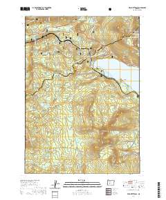
2020 Map of Willamette Pass
USGS Topo · Published 2020About this map
The high Cascade crest at Willamette Pass anchors this mapping of the border between Willamette National Forest and Deschutes National Forest. The landscape is defined by its recreation and transportation corridors, where the Pacific Crest National Scenic Trail winds through a high-altitude basin of numerous alpine lakes, including Midnight Lake, Arrowhead Lake, and Yoran Lake. A significant geological and recreational landmark, Salt Creek Falls sits near the northern boundary, while the expansive waters of Odell Lake dominate the eastern section with points such as Breezy Point and Shelter Cove.
Find a feature on this map
87 named features on this map. Tap any name to fly to it.
Don’t see what you’re looking for? This feature index may not catch every label — zoom into the map to look around manually.
Map Details
Editions of this 2020 Willamette Pass Map
This is the sole edition of this map. No revisions or reprints were ever made.
Other maps of this area

1917 · Diamond Lake
USGS Topo · 1:125,000

1925 · Waldo Lake
USGS Topo · 1:125,000

1930 · Maiden Peak
USGS Topo · 1:125,000

1934 · Maiden Peak
USGS Topo · 1:125,000

1935 · Chemult
USGS Topo · 1:96,000

1941 · Chemult
USGS Topo · 1:125,000

1955 · Crescent
USGS Topo · 1:250,000

1956 · Waldo Lake
USGS Topo · 1:62,500

1956 · Summit Lake
USGS Topo · 1:62,500

1957 · Crescent
USGS Topo · 1:250,000