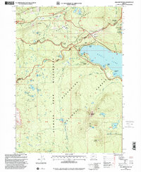
1997 Map of Willamette Pass
USGS Topo · Published 2001About this map
Odell Lake dominates the high-altitude landscape of this 1990s revision, serving as a focal point for the surrounding wilderness and recreational infrastructure. The Southern Pacific railroad line winds through the mountains, passing through Cascade Summit and Pengra Pass, highlighting the historical importance of this corridor for trans-Cascadian transportation. The area is a nexus for outdoor activity, featuring the Willamette Pass Ski Area and various shelters like the Bechtel Shelter and Westview Shelter.
Find a feature on this map
66 named features on this map. Tap any name to fly to it.
Don’t see what you’re looking for? This feature index may not catch every label — zoom into the map to look around manually.
Map Details
Editions of this 1997 Willamette Pass Map
This is the sole edition of this map. No revisions or reprints were ever made.
Other maps of this area

1917 · Diamond Lake
USGS Topo · 1:125,000

1925 · Waldo Lake
USGS Topo · 1:125,000

1930 · Maiden Peak
USGS Topo · 1:125,000

1934 · Maiden Peak
USGS Topo · 1:125,000

1935 · Chemult
USGS Topo · 1:96,000

1941 · Chemult
USGS Topo · 1:125,000

1955 · Crescent
USGS Topo · 1:250,000

1956 · Waldo Lake
USGS Topo · 1:62,500

1956 · Summit Lake
USGS Topo · 1:62,500

1957 · Crescent
USGS Topo · 1:250,000