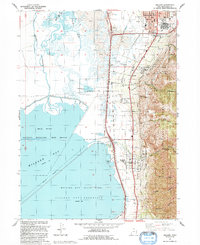
1992 Map of Willard
USGS Topo · Published 1992About this map
The eastern shores of Willard Bay and the steep slopes of the Cache National Forest define the geography of this Box Elder County region in the early 1990s. The settled corridor between the mountains and the water follows the Union Pacific rail line and several historic irrigation routes, including the Willard Canal and Perry Canal. This map captures a landscape managed for both industry and recreation, where the Willard Bay State Park and North Marina sit just west of active gravel operations and a quarry tucked into the canyons. Local history is anchored by the established streets of Brigham City at the northern edge and the town of Willard to the south. Notable landmarks for genealogists and researchers include a local cemetery and the Willard City Spring, alongside numerous named drainages such as Perry Canyon and Cook Canyon.
Find a feature on this map
51 named features on this map. Tap any name to fly to it.
Don’t see what you’re looking for? This feature index may not catch every label — zoom into the map to look around manually.
Map Details
Editions of this 1992 Willard Map
This is the sole edition of this map. No revisions or reprints were ever made.
Other maps of this area

1914 · Logan
USGS Topo · 1:125,000

1916 · Logan
USGS Topo · 1:125,000

1954 · Whistler Canal
USGS Topo · 1:24,000

1954 · Ogden
USGS Topo · 1:250,000

1954 · Brigham City
USGS Topo · 1:250,000

1955 · Plain City
USGS Topo · 1:24,000

1955 · Mantua
USGS Topo · 1:24,000

1955 · Plain City SW
USGS Topo · 1:24,000

1955 · Bear River City
USGS Topo · 1:24,000

1955 · Willard
USGS Topo · 1:24,000