
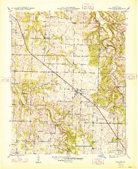
1948 Map of Willard
USGS Topo · Published 1948About this map
The St Louis San Francisco railroad cuts a sharp diagonal through this Greene County landscape, anchoring the development of Willard and nearby rural communities shortly after World War II. The map reveals a dense network of local schools and churches that served the agricultural population, including Friendship Ch and Mt Pleasant Ch. Waterways like the Little Sac River and Asher Creek are crossed by named landmarks such as the Hackney Mill Bridge and Johnson Ford Bridge, indicating the importance of these crossings for local commerce and travel. Near the southern edge, the Springfield Airport and Clear Creek Park represent the encroaching modern infrastructure of the neighboring city, while the interior remains defined by family-named landmarks and small settlements like Pearl, Cave Spring, and Ritter.
Find a feature on this map
37 named features on this map. Tap any name to fly to it.
Don’t see what you’re looking for? This feature index may not catch every label — zoom into the map to look around manually.
Map Details
Editions of this 1948 Willard Map
2 editions found
Other maps of this area

1884 · Springfield
USGS Topo · 1:125,000

1886 · Greenfield
USGS Topo · 1:125,000

1886 · Springfield
USGS Topo · 1:125,000

1888 · Greenfield
USGS Topo · 1:125,000

1919 · Halltown
USGS Topo · 1:62,500

1935 · Springfield
USGS Topo · 1:24,000

1936 · Brookline
USGS Topo · 1:24,000

1948 · Ebenezer
USGS Topo · 1:24,000

1954 · Springfield
USGS Topo · 1:250,000

1956 · Ash Grove
USGS Topo · 1:24,000