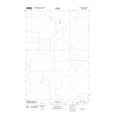
2011 Map of Willard SE
USGS Topo · Published 2011About this map
Little Beaver Creek and its many meandering tributaries define this portion of the Montana prairie in southeastern Fallon County. The landscape is a network of drainage basins, where Duck Creek and the South Fork Duck Creek flow through the northern reaches, while Fletcher Creek and Hay Creek carve through the southern sections. This 2011 survey captures the region's ranching and water management infrastructure, most notably the Traweek Number 2 Dam which impounds water in the upper coulees. Human presence is marked by a sparse but vital grid of rural roads, including Webster Rd and County Hwy-247, which provide the primary access through this open rangeland. The map illustrates a classic Great Plains drainage pattern where intermittent and perennial streams create a complex topography essential for local livestock operations.
Find a feature on this map
9 named features on this map. Tap any name to fly to it.
Don’t see what you’re looking for? This feature index may not catch every label — zoom into the map to look around manually.
Map Details
Editions of this 2011 Willard SE Map
This is the sole edition of this map. No revisions or reprints were ever made.
Other maps of this area

1953 · Miles City
USGS Topo · 1:250,000

1954 · Ekalaka
USGS Topo · 1:250,000

1956 · Ekalaka
USGS Topo · 1:250,000

1957 · Miles City
USGS Topo · 1:250,000

1958 · Miles City
USGS Topo · 1:250,000

1958 · Ekalaka
USGS Topo · 1:250,000

1965 · Ekalaka
USGS Topo · 1:250,000

1980 · Dutchmans Hill
USGS Topo · 1:24,000
1980 · Flasted Hill
USGS Topo · 1:24,000
1980 · Terrell Creek
USGS Topo · 1:24,000