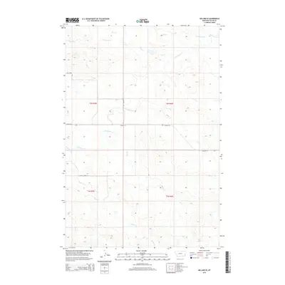
2014 Map of Willard SE
USGS Topo · Published 2014About this map
Little Beaver Cr and Duck Cr wind through the southeastern reaches of Fallon County, defining a drainage system that has long shaped movement and land use in this part of Montana. The 2014 landscape remains characterized by its remote ranching infrastructure, where long-standing corridors like Webster Rd and the utilitarian Shelterbelt Rd provide the primary connections across the township lines of t4n r59e and t4n r60e. The density of watercourses, including the smaller Bone Pile Cr and the extensive Fletcher Cr network, suggests a terrain deeply etched by seasonal hydrology. Historically, the presence of the Fletcher Creek Trl reflects the enduring reliance on specific natural passages for navigating these high plains. This map captures the intersection of early public land surveys and contemporary rural access, preserving the exact layout of the drainage basins and the section-line roads that serve this agricultural interior.
Find a feature on this map
15 named features on this map. Tap any name to fly to it.
Don’t see what you’re looking for? This feature index may not catch every label — zoom into the map to look around manually.
Map Details
Editions of this 2014 Willard SE Map
This is the sole edition of this map. No revisions or reprints were ever made.
Other maps of this area

1953 · Miles City
USGS Topo · 1:250,000

1954 · Ekalaka
USGS Topo · 1:250,000

1956 · Ekalaka
USGS Topo · 1:250,000

1957 · Miles City
USGS Topo · 1:250,000

1958 · Miles City
USGS Topo · 1:250,000

1958 · Ekalaka
USGS Topo · 1:250,000

1965 · Ekalaka
USGS Topo · 1:250,000

1980 · Dutchmans Hill
USGS Topo · 1:24,000
1980 · Flasted Hill
USGS Topo · 1:24,000
1980 · Terrell Creek
USGS Topo · 1:24,000