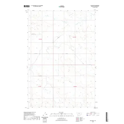
2020 Map of Willard SE
USGS Topo · Published 2020About this map
Little Beaver Cr and Hay Cr drain this expansive prairie landscape in southeastern Fallon County, where the terrain is marked by a complex network of intermittent stream beds and drainage coulees. The map illustrates a rural area defined by section lines and grazing land, with movement facilitated by long, straight gravel routes such as Shelterbelt Rd and Webster Rd. Local topography is highlighted by named drainages like Bone Pile Cr and Fletcher Cr, which cut through the high plains toward the larger creek systems. These waterways and the corresponding Fletcher Creek Trl indicate a landscape primarily utilized for ranching and large-scale agriculture. The distribution of these features reveals a settlement pattern common to Eastern Montana, where life and transit are dictated by the presence of water sources and the grid of established section roads.
Find a feature on this map
15 named features on this map. Tap any name to fly to it.
Don’t see what you’re looking for? This feature index may not catch every label — zoom into the map to look around manually.
Map Details
Editions of this 2020 Willard SE Map
This is the sole edition of this map. No revisions or reprints were ever made.
Other maps of this area

1953 · Miles City
USGS Topo · 1:250,000

1954 · Ekalaka
USGS Topo · 1:250,000

1956 · Ekalaka
USGS Topo · 1:250,000

1957 · Miles City
USGS Topo · 1:250,000

1958 · Miles City
USGS Topo · 1:250,000

1958 · Ekalaka
USGS Topo · 1:250,000

1965 · Ekalaka
USGS Topo · 1:250,000

1980 · Dutchmans Hill
USGS Topo · 1:24,000
1980 · Flasted Hill
USGS Topo · 1:24,000
1980 · Terrell Creek
USGS Topo · 1:24,000