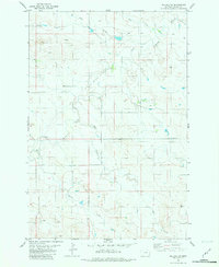
1981 Map of Willard SE
USGS Topo · Published 1981About this map
Little Beaver Creek and its numerous tributaries dominate this southeastern Montana landscape in the early 1980s. The map reveals a high-plains terrain defined by seasonal water drainage patterns, including South Fork Duck Creek in the northwest and the winding path of Fletcher Creek to the south. The presence of several wells, including a specific Flowing Well in the southeast corner, suggests the critical importance of groundwater management for ranching in this arid environment. Smaller drainages like Bone Pile Creek and Hay Creek carve through the topography, illustrating the complex watershed system that feeds into the larger basins of Fallon County.
Find a feature on this map
10 named features on this map. Tap any name to fly to it.
Don’t see what you’re looking for? This feature index may not catch every label — zoom into the map to look around manually.
Map Details
Editions of this 1981 Willard SE Map
This is the sole edition of this map. No revisions or reprints were ever made.
Other maps of this area

1953 · Miles City
USGS Topo · 1:250,000

1954 · Ekalaka
USGS Topo · 1:250,000

1956 · Ekalaka
USGS Topo · 1:250,000

1957 · Miles City
USGS Topo · 1:250,000

1958 · Miles City
USGS Topo · 1:250,000

1958 · Ekalaka
USGS Topo · 1:250,000

1965 · Ekalaka
USGS Topo · 1:250,000

1980 · Dutchmans Hill
USGS Topo · 1:24,000
1980 · Flasted Hill
USGS Topo · 1:24,000
1980 · Terrell Creek
USGS Topo · 1:24,000