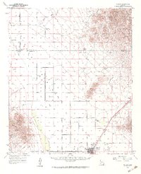
1958 Map of Willcox
USGS Topo · Published 1962About this map
Willcox serves as the focal point for this high-desert basin, situated at the base of the Pinaleno Mountains and Winchester Mountains. By the late 1950s, the town's infrastructure reflects its role as a regional hub, featuring the Southern Pacific railroad line, a Golf Course, and the Drive-in Theater. The surrounding landscape is defined by vast cattle ranching operations and natural drainages such as Sacaton Draw and Campomocho Draw.
Find a feature on this map
52 named features on this map. Tap any name to fly to it.
Don’t see what you’re looking for? This feature index may not catch every label — zoom into the map to look around manually.
Map Details
Editions of this 1958 Willcox Map
3 editions found

Other maps of this area

1922 · Willcox
USGS Topo · 1:125,000

1940 · Sierra Bonita Ranch
USGS Topo · 1:62,500

1942 · Sierra Bonita Ranch
USGS Topo · 1:62,500

1942 · Mt. Graham
USGS Topo · 1:62,500

1943 · Dos Cabezas
USGS Topo · 1:62,500

1943 · Willcox
USGS Topo · 1:62,500

1943 · Cochise
USGS Topo · 1:62,500

1943 · Dragoon
USGS Topo · 1:62,500

1943 · Sierra Bonita Ranch
USGS Topo · 1:62,500

1943 · Winchester Mts.
USGS Topo · 1:62,500