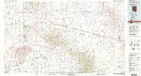
1994 Map of Willcox
USGS Topo · Published 1994About this map
Sulphur Springs Valley dominates this 1994 topographic study, centered on the historic cattle and rail hub of Willcox. The landscape is a study in High Desert extremes, featuring the massive Willcox Playa and Willcox Dry Lake, which also served as the Willcox Bombing Range. To the east, the Dos Cabezas Mountains and Chiricahua Mountains rise sharply, punctuated by historic mining operations such as the Mascot Mine and Gold Prince Mine. The map traces the critical transit corridor of the Southern Pacific railroad and Interstate 10, connecting settlements like Bowie, San Simon, and Cochise. Local history is deeply embedded in the terrain, from the Fort Bowie National Historic Site at Apache Pass to the scattered agricultural outposts of Kansas Settlement and Luzena. The presence of the Old Military Reservation Boundary reflects the region's 19th-century frontier importance.
Find a feature on this map
102 named features on this map. Tap any name to fly to it.
Don’t see what you’re looking for? This feature index may not catch every label — zoom into the map to look around manually.
Map Details
Editions of this 1994 Willcox Map
2 editions found
Other maps of this area

1915 · Benson
USGS Topo · 1:125,000

1916 · Pearce
USGS Topo · 1:125,000

1917 · San Simon
USGS Topo · 1:125,000

1917 · Chiricahua
USGS Topo · 1:125,000

1918 · Pratt
USGS Topo · 1:62,500

1919 · Pratt
USGS Topo · 1:62,500

1919 · Chiricahua
USGS Topo · 1:125,000

1922 · Willcox
USGS Topo · 1:125,000

1922 · St. David
USGS Topo · 1:62,500

1926 · Light
USGS Topo · 1:62,500