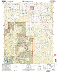
2004 Map of Willhoit
USGS Topo · Published 2006About this map
Mark Twain National Forest dominates this section of the Ozarks, where the terrain is defined by a dense network of hollows such as Thompson Hollow and Bennett Hollow. The settlement pattern reflects a classic rural Missouri landscape of small, dispersed communities including Nottinghill, Willhoit, and Romance. Water is central to the area's geography, with the South Fork and Turkey Creek winding through the hills toward the southern reach of Bull Shoals Lake.
Find a feature on this map
37 named features on this map. Tap any name to fly to it.
Don’t see what you’re looking for? This feature index may not catch every label — zoom into the map to look around manually.
Map Details
Editions of this 2004 Willhoit Map
This is the sole edition of this map. No revisions or reprints were ever made.
Other maps of this area

1934 · Gainesville
USGS Topo · 1:48,000

1936 · Thornfield
USGS Topo · 1:48,000

1936 · Ava
USGS Topo · 1:48,000

1937 · Buckhart
USGS Topo · 1:48,000

1940 · Gainesville
USGS Topo · 1:62,500

1942 · Ava
USGS Topo · 1:62,500

1943 · Thornfield
USGS Topo · 1:62,500

1943 · Buckhart
USGS Topo · 1:62,500

1945 · Ava
USGS Topo · 1:62,500

1945 · Harrison
USGS Topo · 1:250,000