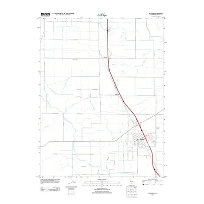
2012 Map of Williams
USGS Topo · Published 2012About this map
The town of Williams serves as the primary hub in this central California landscape, where the agricultural grid meets major transport corridors. This 2012 survey documents the intricate water management system essential to the region, most notably the prominent Glenn-Colusa Canal which snakes across the valley floor alongside natural drainages like Glenn Valley Slough and Freshwater Creek. Small railway-aligned settlements such as Cortena and Delphos appear along the Old Hwy 99W corridor, reflecting the historical movement patterns of Colusa County before the modern interstate era. The map provides a precise look at the local infrastructure surrounding the town center, including the Williams Airport and the local Post Office, set against a backdrop of named country roads and irrigation laterals that define the modern rural economy.
Find a feature on this map
42 named features on this map. Tap any name to fly to it.
Don’t see what you’re looking for? This feature index may not catch every label — zoom into the map to look around manually.
Map Details
Editions of this 2012 Williams Map
This is the sole edition of this map. No revisions or reprints were ever made.
Other maps of this area

1904 · Sites
USGS Topo · 1:24,000

1905 · Fairview
USGS Topo · 1:24,000

1906 · Maxwell
USGS Topo · 1:62,500

1907 · Colusa
USGS Topo · 1:62,500

1917 · Compton Landing
USGS Topo · 1:31,680

1917 · Sites
USGS Topo · 1:31,680

1917 · Delevan
USGS Topo · 1:31,680

1918 · Williams
USGS Topo · 1:31,680

1918 · Spring Valley
USGS Topo · 1:31,680
1918 · Arbuckle
USGS Topo · 1:31,680