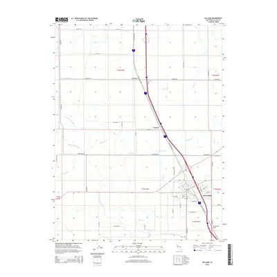
2015 Map of Williams
USGS Topo · Published 2015About this map
The town of Williams serves as the primary hub of activity in this portion of Colusa County, where the grid of city streets like N St and H St meets the modern alignment of the Interstate and the traditional path of Old Highway 99W. The surrounding landscape is defined by an extensive network of agricultural irrigation and drainage, anchored by the Glenn-Colusa Canal and supported by numerous natural waterways including Freshwater Cr and Salt Cr. Smaller rural localities such as Cortena and Delphos sit along the north-south transit corridor, marking points of interest in a region primarily dedicated to large-scale cultivation. This 2015 survey illustrates how traditional water management systems like the Freshwater Lateral and Glenn Valley Slough continue to shape the development of the Sacramento Valley, preserving the distinct boundaries of the Public Land Survey System that organize the area into neat sections.
Find a feature on this map
57 named features on this map. Tap any name to fly to it.
Don’t see what you’re looking for? This feature index may not catch every label — zoom into the map to look around manually.
Map Details
Editions of this 2015 Williams Map
This is the sole edition of this map. No revisions or reprints were ever made.
Other maps of this area

1904 · Sites
USGS Topo · 1:24,000

1905 · Fairview
USGS Topo · 1:24,000

1906 · Maxwell
USGS Topo · 1:62,500

1907 · Colusa
USGS Topo · 1:62,500

1917 · Compton Landing
USGS Topo · 1:31,680

1917 · Sites
USGS Topo · 1:31,680

1917 · Delevan
USGS Topo · 1:31,680

1918 · Williams
USGS Topo · 1:31,680

1918 · Spring Valley
USGS Topo · 1:31,680
1918 · Arbuckle
USGS Topo · 1:31,680