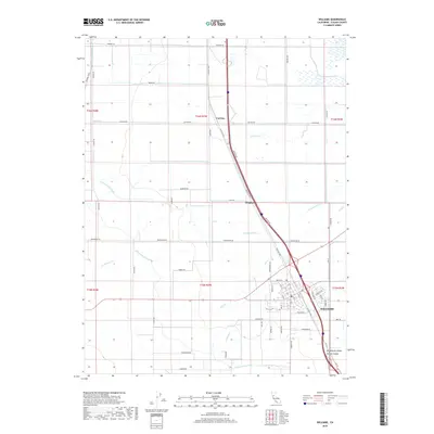
2018 Map of Williams
USGS Topo · Published 2018About this map
Williams stands as a central hub in Colusa County, defined by its rigid street grid and proximity to the vital Glenn-Colusa Canal. The landscape illustrates the high-efficiency agricultural development of the Sacramento Valley, where numerous lateral canals and sloughs like Freshwater Lat and Glenn Valley Slough manage the water flow across the flat terrain. Local transit is dominated by the historical alignment of Old Hwy 99W and Delphas Rd, which connect the main town to smaller outlying locations such as Cortena and Delphos. The township system is clearly visible through the numerous section-line roads, including Marengo Rd and Freshwater Rd, which partition the territory into large industrial farming plots typical of this region's modern land use.
Find a feature on this map
66 named features on this map. Tap any name to fly to it.
Don’t see what you’re looking for? This feature index may not catch every label — zoom into the map to look around manually.
Map Details
Editions of this 2018 Williams Map
This is the sole edition of this map. No revisions or reprints were ever made.
Other maps of this area

1904 · Sites
USGS Topo · 1:24,000

1905 · Fairview
USGS Topo · 1:24,000

1906 · Maxwell
USGS Topo · 1:62,500

1907 · Colusa
USGS Topo · 1:62,500

1917 · Compton Landing
USGS Topo · 1:31,680

1917 · Sites
USGS Topo · 1:31,680

1917 · Delevan
USGS Topo · 1:31,680

1918 · Williams
USGS Topo · 1:31,680

1918 · Spring Valley
USGS Topo · 1:31,680
1918 · Arbuckle
USGS Topo · 1:31,680