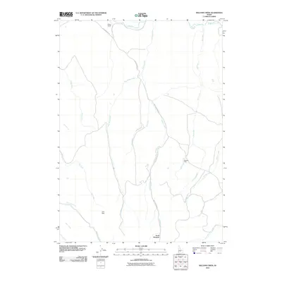
2010 Map of Williams Creek
USGS Topo · Published 2010About this map
South Mountain anchors this Owyhee County landscape, where a network of seasonal and perennial streams carves through the high Idaho terrain. The primary transportation artery, South Mountain Rd, winds through the central and western sections, tracing the drainage patterns of Williams Creek and Pole Bridge Creek. Water management is represented by Pershall Dam along Rail Creek, a significant point of infrastructure in an otherwise largely undeveloped environment dominated by grazing and watershed features. To the west, Jims Peak stands as a prominent topographical landmark above the headwaters of Owl Creek and Lone Tree Creek. The nomenclature across the quadrangle, including Iron Mine Creek and Cattle Creek, suggests a history of local industry and ranching. Other distinct landforms like Glass Gulch near Jordan Creek further define the intricate drainage network characteristic of the region.
Find a feature on this map
21 named features on this map. Tap any name to fly to it.
Don’t see what you’re looking for? This feature index may not catch every label — zoom into the map to look around manually.
Map Details
Editions of this 2010 Williams Creek Map
This is the sole edition of this map. No revisions or reprints were ever made.
Other maps of this area

1955 · Jordan Valley
USGS Topo · 1:250,000

1957 · Jordan Valley
USGS Topo · 1:250,000

1958 · Jordan Valley
USGS Topo · 1:250,000

1965 · Flint Creek
USGS Topo · 1:62,500
1969 · Jordan Valley
USGS Topo · 1:24,000

1973 · Indian Meadows
USGS Topo · 1:24,000

1973 · Cliffs
USGS Topo · 1:24,000

1980 · Juniper Point
USGS Topo · 1:24,000
1990 · Triangle
USGS Topo · 1:100,000
1990 · Flint
USGS Topo · 1:24,000