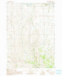
1990 Map of Williams Creek
USGS Topo · Published 1991About this map
South Mountain dominates the southern landscape of this Owyhee County region, which is marked by a complex network of canyons and high-elevation drainages. In the late 20th century, the area remained defined by its mineral prospects and rugged accessibility, as evidenced by numerous adits, prospects, and a specific Mine Shaft located along the upper reaches of Williams Creek. Water management for high-desert ranching is visible via the Pleasant Valley Ditch drawing from Jordan Creek in the north. The presence of a remote Landing Strip near Glass Gulch underscores the isolation of these uplands, where travel relied heavily on 4WD tracks. From the peaks of Jims Peak to the deep cuts of Iron Mine Creek and Rail Creek, the map provides a look at the interplay between high-country topography and the persistent search for ore and water.
Find a feature on this map
30 named features on this map. Tap any name to fly to it.
Don’t see what you’re looking for? This feature index may not catch every label — zoom into the map to look around manually.
Map Details
Editions of this 1990 Williams Creek Map
This is the sole edition of this map. No revisions or reprints were ever made.
Other maps of this area

1955 · Jordan Valley
USGS Topo · 1:250,000

1957 · Jordan Valley
USGS Topo · 1:250,000

1958 · Jordan Valley
USGS Topo · 1:250,000

1965 · Flint Creek
USGS Topo · 1:62,500
1969 · Jordan Valley
USGS Topo · 1:24,000

1973 · Indian Meadows
USGS Topo · 1:24,000

1973 · Cliffs
USGS Topo · 1:24,000

1980 · Juniper Point
USGS Topo · 1:24,000
1990 · Triangle
USGS Topo · 1:100,000
1990 · Flint
USGS Topo · 1:24,000