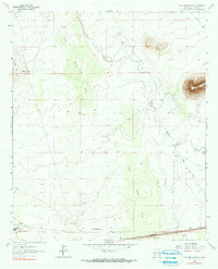
1964 Map of Williams Ranch
USGS Topo · Published 1972About this map
Williams Ranch and the small settlement of Tunis anchor this high-desert landscape in Luna County during the mid-1960s. The Southern Pacific railroad runs along the southern edge, paralleling a significant Pipeline and a Landing Strip, illustrating the importance of transit and utility infrastructure in this arid region. The ephemeral Mimbres River cuts through the center of the sheet, supported by the Wamel Canal and a network of water-management features including a Gaging Sta, North Windmill, and South Windmill.
Find a feature on this map
19 named features on this map. Tap any name to fly to it.
Don’t see what you’re looking for? This feature index may not catch every label — zoom into the map to look around manually.
Map Details
Editions of this 1964 Williams Ranch Map
2 editions found
Other maps of this area

1899 · Deming
USGS Topo · 1:125,000

1915 · Deming
USGS Topo · 1:125,000

1954 · Silver City
USGS Topo · 1:250,000

1955 · Las Cruces
USGS Topo · 1:250,000

1958 · Las Cruces
USGS Topo · 1:250,000

1958 · Silver City
USGS Topo · 1:250,000

1962 · Silver City
USGS Topo · 1:250,000
1963 · Antelope Hill
USGS Topo · 1:24,000

1963 · Gage
USGS Topo · 1:24,000
1964 · Grandmother Mountain East
USGS Topo · 1:24,000